When the Land Screams: Tuti’s Tāya

When the Land Screams: Tuti’s Tāya
When bodies are used as flood defence and Survival is engineered through resistance
(This is a tale of a community that guarded its heritage against erasure and were protected by their land in return.)
An island at the confluence of the Nile, when geography shapes fate
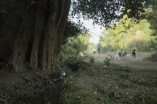
In the heart of Sudan’s capital, where the White Nile and Blue Nile converge, the green expanse of Tuti Island stretches out, as if it were put there deliberately to connect the two rivers or perhaps as a testing ground.
The island is a complex geographical formation bordered to the east by Khartoum North, to the south by Khartoum, and to the west by Omdurman. Above it, the open sky offers no shelter and around it is an unpredictable river which at times arrives to deposit silt while at others, it carries raging flood waters.
Tuti’s geographic formation makes it, in addition to being an agricultural island spanning approximately 950 feddans, a constant testing ground for survival. Being surrounded by water, with no natural barriers and rising only a few metres above the Nile, flooding is not a seasonal anomaly but a regular, annual occurrence. For the island’s inhabitants, there was no choice but to become adept at ‘reading the river’ in order to anticipate any flooding. They have developed into experts of hydrology and in engineering solutions before the waters rise and start lapping at their doorsteps. While in some places disaster protection systems are designed on paper in air-conditioned rooms, in Tuti, the tāya system is designed on the land using human bodies and heritage. In this way, a geographic liability was transformed into a gateway for innovation, and life-threatening danger became an incentive for solidarity and building collective memory. The tāya was not a temporary measure taken during flooding but has developed into permanent means of resistance that is reconfigured every year with the change of water, land and people.
But what is the tāya? In Tuti, the tāya is a tent that is put up at the first signs of flooding. Inside the tent work begins and roles are distributed with one team tasked with monitoring water levels day and night, another tends to those stung by the insects and scorpions that emerge with the rising water while yet another team moves the furniture out of at-risk homes, distribute food and keep up precise and regular lines of communication. This makeshift emergency headquarters of fabric walls on mud ground and filled with good intentions emerges in moments of need and is dismantled as the danger recedes. The tāya is what people build in the absence of institutions and when all they have is one another.
From bodies holding back the water to a system that teaches how to prevent drowning
Tuti’s tāya was not a written system or project created by an institution, but was the result of an act of disobedience. In 1944, when the British colonial governor ordered the evacuation of the island to make way for his imperial projects, the people stood in quiet defiance, a silence rooted in certainty. Their objection was just the beginning, the floods completed the story.
When flooding occurred in Tuti in 1946, the colonial authorities retreated, leaving the residents to face the rising waters on their own. These in turn, did not cry out for help or flee the island, but instead, they formed a barricade with their bodies to stop the water and thus, they built the first tāya out of nothing.
This was the first collective exercise in self-protection. Over time, this act of flood-prevention, was developed evolving into a social and architectural system that was rooted in popular memory. Every year the tāya was revived in accordance to local conditions and became a system that is alive, transforms and is passed down through generations. This ‘architecture of survival’ was how Tuti’s tāya became one of the most ingenious examples of communal solidarity in the face of natural disaster and neglect.
When the warning is silt and the missing sound of a bird
In Tuti, the tāya is not an echo of sirens but an awareness of what is absent. When the blue water of the Nile changes into a sinister hue, when the cormorant vanishes, when the smell of clay recedes and it becomes extremely moist. These are the signs of flooding that are not captured by instruments but by those who have lived near the river for so long they are able to understand its murmurs. Tuti’s children are not given theoretical lessons about these signs, they inherit them through stories and casual conversations and spontaneous play on the riverbank. The moment the tāya is declared there is no shouting and no alarms are sounded but there is an immediate shift from ordinary life to a life of vigilance, where every person knows their place just as surely as they know their own name.
When the community becomes one
The tāya is a living embodiment of collective organisation where the entire neighbourhood is transformed into a network of human nodes. In terms of women, the tāya system highlights the central, familiar role of Tuti’s women, one that extends far beyond traditional stereotypes.
This includes the skill of observation whereby many women, especially older women with long experience, were skilled in reading the signs of the river and the sky. Their confidence in these interpretations was often decisive in the decision of whether to call for tāya. The women also had an active and effective role in assessing the situation and debating the need to raise the alarm and their opinions were respected in informal councils. During and after the alarm, women played a central role in allaying fears, organising the transport of children and the elderly and securing essential supplies in a way that would ensure life could go on amid potential chaos. It was a form of quiet, yet powerful, community leadership. They prepared food in the courtyards of mosques, not only for their own menfolk, but for the strangers who had become brothers in the cause.
The elders would watch the river as though reading a will written upon its surface. The young men carried mud on their shoulders while some would fill sacks with stones taken from the remains of a collapsed wall. Even the children knew the weak points along the barriers and which corners needed reinforcing with more clay.
Every home becomes a supply station, every street a lifeline, and every courtyard a tāya command post whose doors never close. During this time life is not only reshaped, but the community’s very capacity is tested, its ability to form a self-reliant system, without the need for any outsiders.
1946 when bodies replaced mud
In October 1946, when the Nile was in spate, the small island stood up to face it with no equipment, funding or promises of help. The men gathered along the banks, arms interlocked, their legs submerged to the knees, their sleep-deprived eyes focussed. In storage rooms food was emptied out of their sacks without hesitation so that they could be used as sandbags—for water does not wait anything. Women mixed mud with water their bodies transformed into factories for making urgent clay bricks.
When the news reached the world
The following passage is based on a dramatized, yet realistic, simulation inspired by the testimonies of Tuti’s residents. It aims to bring the sensory image closer to the reader without compromising the on-the-ground reality of community practices. What was happening in Tuti was no secret. When news of the community’s self-organisation reached international institutions, the United Nations sent a delegation of experts. They saw with their own eyes: a man reading rising water levels using a notched stick; a young girl rushing to save her deaf neighbour; a woman burying seeds in a clay pot, so that life could return after the flood. One of them remarked in astonishment “this is not disaster management… this is a celebration of life in the face of death!”
Between the roar of war and the whisper of the flood: today’s Tāya is on a knife’s edge
Since the outbreak of war in 2023, the tāya has not been what it once was. The community that once operated as a single, synchronised body has become fractured under the weight of displacement, absence, and fear. Participation has declined, families have been scattered, and the cost of living has soared. The sand that was once gathered from the shore must now be bought or replaced with rubble from destroyed houses. There are only seven of the experts who know how to build the barricade left on the island. And yet, the tāya has not disappeared. The greater the danger, the more stubborn it becomes. It does not require numbers to function, only memory, and memory does not die; it passes from one person to another.
Contemporary challenges: will the sound of the Tāya fall silent?
Today, this ingenious heritage faces existential threats.
Climate change: Flood patterns have grown more extreme and unpredictable. Sudden, violent inundations or unprecedented droughts now challenge the precision of traditional observation—once rooted in relatively stable historical rhythms, according to the Intergovernmental Panel on Climate Change’s reports on the Nile Basin region.
Urban expansion and infrastructure: New dams have altered the Nile’s channels, and the urban sprawl of Khartoum and Omdurman are reshaping the dynamics of water flow around Tuti, changes that the old tāya system may not fully account for.
Displacement and eroded cohesion: The displacement of families and mounting economic pressures have, in many ways, weakened the organic social cohesion that once fuelled the tāya system. Passing on this knowledge to new generations now requires conscious, deliberate effort.
The Tāya is not a tent, but a sixth sense born of place and people.
In Tuti, barricades are built with clay and a lot of trust. The tāya itself is not declared because the state demands it, but when geography gives the sign and lessons are memorised from history. Here, water is not a seasonal crisis but a recurring test of the people’s ability to remember themselves as a community, not as individuals.
With every flood season, the residents reactivate their communal memory. No one asks another “What should I do?”—action begins instinctively, as if collective consciousness had anticipated the question. Only communities that have learned to live beside the river without being overcome by it can create such a system that becomes part of these people’s practiced heritage.
Tuti’s tāya is not a romanticised memory, but a living socio-ecological system that teaches us:
How to protect ourselves, how to read the signs of the land and how to save one another without waiting for an official alarm. In the age of satellite communication and apps, the form of the tāya may change, but it will live on so long as the island believes that true warning begins with awareness, and that survival begins when we listen to the river’s murmers—not its screams.
From Tuti’s Tāya to Aba Island: why this genius means of survival did not spread across Sudan?
When the White Nile floods its banks at Aba Island, or when Sennar, al-Rusayris, al-Dinder, or even the outskirts of Nyala are submerged… where does this ingenuity hide? And why is Tuti’s tāya not replicated there?
On Aba Island, people confront floods with the same spirit of resistance, but in a less organised manner. Local residents rely on traditional mud barricades, sandbag buttresses, and communal effort. Organisations and the state often act too late, or not at all. And yet, life goes on.
In Al-Dinder, where soil becomes mud traps, instinctive forms of tāya have emerged. Residents raise their houses on stone or mud foundations and build makeshift barriers out of leftover construction materials. While no one has given this practice a specific name, everyone understands that what they are building is a lifeline. In these areas, ‘survival’ is shaped more by community partnership than by technical knowhow, and more by lived experience than by formal study. In Nyala and Sennar, as the effects of climate change intensify, erratic floods have become more frequent. Solutions are often improvised and lack sustainability, forcing communities to rebuild their homes year after year. Small projects—retaining walls or drainage channels—quickly erode in the face of torrential rains. Some villages draw inspiration from what they have seen on television of Tuti’s tāya, but without technical guidance or structural support.
So, questions remain:
If the tāya emerged out of necessity and was engineered locally, why didn’t it spread to other regions confronted with similar circumstances? And why isn’t it shared as a form of knowledge? And finally, why weren’t any community protection policies built around them?
Perhaps the answer has nothing to do with engineering. Tuti’s tāya was never only about clay barricades, it was an expression of a profound understanding of the terrain, a confidence in collective selfhood, and the distillation of flood memory into architecture. Other regions lacked this type of documentation, this communal recognition and this vital link between individual experience and the common good. And perhaps—just as the state fails to distribute resources equitably—it fails to generalise the use of such a creative system because it is made by the people and not by officials.
Author’s note:
Some passages describe imagined scenes, but they are grounded in oral heritage and in the documented practices of Tuti’s community during times of flood. They have been written in a descriptive style to bring the sensory and intellectual experience closer to the reader, without compromising the reality of events or the credibility of the community system portrayed.
This type of narrative is known in heritage studies as “interpretive simulation” and is used to embody human values that cannot easily be interpreted in technical language alone.
Cover picture taken by Zainab Gaafar
When bodies are used as flood defence and Survival is engineered through resistance
(This is a tale of a community that guarded its heritage against erasure and were protected by their land in return.)
An island at the confluence of the Nile, when geography shapes fate
In the heart of Sudan’s capital, where the White Nile and Blue Nile converge, the green expanse of Tuti Island stretches out, as if it were put there deliberately to connect the two rivers or perhaps as a testing ground.
The island is a complex geographical formation bordered to the east by Khartoum North, to the south by Khartoum, and to the west by Omdurman. Above it, the open sky offers no shelter and around it is an unpredictable river which at times arrives to deposit silt while at others, it carries raging flood waters.
Tuti’s geographic formation makes it, in addition to being an agricultural island spanning approximately 950 feddans, a constant testing ground for survival. Being surrounded by water, with no natural barriers and rising only a few metres above the Nile, flooding is not a seasonal anomaly but a regular, annual occurrence. For the island’s inhabitants, there was no choice but to become adept at ‘reading the river’ in order to anticipate any flooding. They have developed into experts of hydrology and in engineering solutions before the waters rise and start lapping at their doorsteps. While in some places disaster protection systems are designed on paper in air-conditioned rooms, in Tuti, the tāya system is designed on the land using human bodies and heritage. In this way, a geographic liability was transformed into a gateway for innovation, and life-threatening danger became an incentive for solidarity and building collective memory. The tāya was not a temporary measure taken during flooding but has developed into permanent means of resistance that is reconfigured every year with the change of water, land and people.
But what is the tāya? In Tuti, the tāya is a tent that is put up at the first signs of flooding. Inside the tent work begins and roles are distributed with one team tasked with monitoring water levels day and night, another tends to those stung by the insects and scorpions that emerge with the rising water while yet another team moves the furniture out of at-risk homes, distribute food and keep up precise and regular lines of communication. This makeshift emergency headquarters of fabric walls on mud ground and filled with good intentions emerges in moments of need and is dismantled as the danger recedes. The tāya is what people build in the absence of institutions and when all they have is one another.
From bodies holding back the water to a system that teaches how to prevent drowning
Tuti’s tāya was not a written system or project created by an institution, but was the result of an act of disobedience. In 1944, when the British colonial governor ordered the evacuation of the island to make way for his imperial projects, the people stood in quiet defiance, a silence rooted in certainty. Their objection was just the beginning, the floods completed the story.
When flooding occurred in Tuti in 1946, the colonial authorities retreated, leaving the residents to face the rising waters on their own. These in turn, did not cry out for help or flee the island, but instead, they formed a barricade with their bodies to stop the water and thus, they built the first tāya out of nothing.
This was the first collective exercise in self-protection. Over time, this act of flood-prevention, was developed evolving into a social and architectural system that was rooted in popular memory. Every year the tāya was revived in accordance to local conditions and became a system that is alive, transforms and is passed down through generations. This ‘architecture of survival’ was how Tuti’s tāya became one of the most ingenious examples of communal solidarity in the face of natural disaster and neglect.
When the warning is silt and the missing sound of a bird
In Tuti, the tāya is not an echo of sirens but an awareness of what is absent. When the blue water of the Nile changes into a sinister hue, when the cormorant vanishes, when the smell of clay recedes and it becomes extremely moist. These are the signs of flooding that are not captured by instruments but by those who have lived near the river for so long they are able to understand its murmurs. Tuti’s children are not given theoretical lessons about these signs, they inherit them through stories and casual conversations and spontaneous play on the riverbank. The moment the tāya is declared there is no shouting and no alarms are sounded but there is an immediate shift from ordinary life to a life of vigilance, where every person knows their place just as surely as they know their own name.
When the community becomes one
The tāya is a living embodiment of collective organisation where the entire neighbourhood is transformed into a network of human nodes. In terms of women, the tāya system highlights the central, familiar role of Tuti’s women, one that extends far beyond traditional stereotypes.
This includes the skill of observation whereby many women, especially older women with long experience, were skilled in reading the signs of the river and the sky. Their confidence in these interpretations was often decisive in the decision of whether to call for tāya. The women also had an active and effective role in assessing the situation and debating the need to raise the alarm and their opinions were respected in informal councils. During and after the alarm, women played a central role in allaying fears, organising the transport of children and the elderly and securing essential supplies in a way that would ensure life could go on amid potential chaos. It was a form of quiet, yet powerful, community leadership. They prepared food in the courtyards of mosques, not only for their own menfolk, but for the strangers who had become brothers in the cause.
The elders would watch the river as though reading a will written upon its surface. The young men carried mud on their shoulders while some would fill sacks with stones taken from the remains of a collapsed wall. Even the children knew the weak points along the barriers and which corners needed reinforcing with more clay.
Every home becomes a supply station, every street a lifeline, and every courtyard a tāya command post whose doors never close. During this time life is not only reshaped, but the community’s very capacity is tested, its ability to form a self-reliant system, without the need for any outsiders.
1946 when bodies replaced mud
In October 1946, when the Nile was in spate, the small island stood up to face it with no equipment, funding or promises of help. The men gathered along the banks, arms interlocked, their legs submerged to the knees, their sleep-deprived eyes focussed. In storage rooms food was emptied out of their sacks without hesitation so that they could be used as sandbags—for water does not wait anything. Women mixed mud with water their bodies transformed into factories for making urgent clay bricks.
When the news reached the world
The following passage is based on a dramatized, yet realistic, simulation inspired by the testimonies of Tuti’s residents. It aims to bring the sensory image closer to the reader without compromising the on-the-ground reality of community practices. What was happening in Tuti was no secret. When news of the community’s self-organisation reached international institutions, the United Nations sent a delegation of experts. They saw with their own eyes: a man reading rising water levels using a notched stick; a young girl rushing to save her deaf neighbour; a woman burying seeds in a clay pot, so that life could return after the flood. One of them remarked in astonishment “this is not disaster management… this is a celebration of life in the face of death!”
Between the roar of war and the whisper of the flood: today’s Tāya is on a knife’s edge
Since the outbreak of war in 2023, the tāya has not been what it once was. The community that once operated as a single, synchronised body has become fractured under the weight of displacement, absence, and fear. Participation has declined, families have been scattered, and the cost of living has soared. The sand that was once gathered from the shore must now be bought or replaced with rubble from destroyed houses. There are only seven of the experts who know how to build the barricade left on the island. And yet, the tāya has not disappeared. The greater the danger, the more stubborn it becomes. It does not require numbers to function, only memory, and memory does not die; it passes from one person to another.
Contemporary challenges: will the sound of the Tāya fall silent?
Today, this ingenious heritage faces existential threats.
Climate change: Flood patterns have grown more extreme and unpredictable. Sudden, violent inundations or unprecedented droughts now challenge the precision of traditional observation—once rooted in relatively stable historical rhythms, according to the Intergovernmental Panel on Climate Change’s reports on the Nile Basin region.
Urban expansion and infrastructure: New dams have altered the Nile’s channels, and the urban sprawl of Khartoum and Omdurman are reshaping the dynamics of water flow around Tuti, changes that the old tāya system may not fully account for.
Displacement and eroded cohesion: The displacement of families and mounting economic pressures have, in many ways, weakened the organic social cohesion that once fuelled the tāya system. Passing on this knowledge to new generations now requires conscious, deliberate effort.
The Tāya is not a tent, but a sixth sense born of place and people.
In Tuti, barricades are built with clay and a lot of trust. The tāya itself is not declared because the state demands it, but when geography gives the sign and lessons are memorised from history. Here, water is not a seasonal crisis but a recurring test of the people’s ability to remember themselves as a community, not as individuals.
With every flood season, the residents reactivate their communal memory. No one asks another “What should I do?”—action begins instinctively, as if collective consciousness had anticipated the question. Only communities that have learned to live beside the river without being overcome by it can create such a system that becomes part of these people’s practiced heritage.
Tuti’s tāya is not a romanticised memory, but a living socio-ecological system that teaches us:
How to protect ourselves, how to read the signs of the land and how to save one another without waiting for an official alarm. In the age of satellite communication and apps, the form of the tāya may change, but it will live on so long as the island believes that true warning begins with awareness, and that survival begins when we listen to the river’s murmers—not its screams.
From Tuti’s Tāya to Aba Island: why this genius means of survival did not spread across Sudan?
When the White Nile floods its banks at Aba Island, or when Sennar, al-Rusayris, al-Dinder, or even the outskirts of Nyala are submerged… where does this ingenuity hide? And why is Tuti’s tāya not replicated there?
On Aba Island, people confront floods with the same spirit of resistance, but in a less organised manner. Local residents rely on traditional mud barricades, sandbag buttresses, and communal effort. Organisations and the state often act too late, or not at all. And yet, life goes on.
In Al-Dinder, where soil becomes mud traps, instinctive forms of tāya have emerged. Residents raise their houses on stone or mud foundations and build makeshift barriers out of leftover construction materials. While no one has given this practice a specific name, everyone understands that what they are building is a lifeline. In these areas, ‘survival’ is shaped more by community partnership than by technical knowhow, and more by lived experience than by formal study. In Nyala and Sennar, as the effects of climate change intensify, erratic floods have become more frequent. Solutions are often improvised and lack sustainability, forcing communities to rebuild their homes year after year. Small projects—retaining walls or drainage channels—quickly erode in the face of torrential rains. Some villages draw inspiration from what they have seen on television of Tuti’s tāya, but without technical guidance or structural support.
So, questions remain:
If the tāya emerged out of necessity and was engineered locally, why didn’t it spread to other regions confronted with similar circumstances? And why isn’t it shared as a form of knowledge? And finally, why weren’t any community protection policies built around them?
Perhaps the answer has nothing to do with engineering. Tuti’s tāya was never only about clay barricades, it was an expression of a profound understanding of the terrain, a confidence in collective selfhood, and the distillation of flood memory into architecture. Other regions lacked this type of documentation, this communal recognition and this vital link between individual experience and the common good. And perhaps—just as the state fails to distribute resources equitably—it fails to generalise the use of such a creative system because it is made by the people and not by officials.
Author’s note:
Some passages describe imagined scenes, but they are grounded in oral heritage and in the documented practices of Tuti’s community during times of flood. They have been written in a descriptive style to bring the sensory and intellectual experience closer to the reader, without compromising the reality of events or the credibility of the community system portrayed.
This type of narrative is known in heritage studies as “interpretive simulation” and is used to embody human values that cannot easily be interpreted in technical language alone.
Cover picture taken by Zainab Gaafar

Autumn

Autumn
Autumn is the rainy season in most parts of Sudan and has been connected with local knowledge and traditions related to agriculture, grazing, and seasonal migration. This traditional knowledge derived from astronomic points and stars locations.
It was believed that autumn commenced with the arrival of Pleiades (Al-Thuriya) near (Ib Riya) Orion on May 17th. This is followed by the period known as al-Dubran, lasting from May 30th to June 11th or 12th. then, a shift in wind direction occur and the northward advance of the intertropical convergence zone marks the beginning of the ‘Eyna (the star position) alasa alatchana’ (the thirsty stick) or Elhanaa phase, from June 13th to 25th.
This is then followed by a period of moderated temperature and increased humidity, and then comes “Eyn alasaa alrawyana” (the moist stick) or “al-Hakaa” phase, from June 26th to July 6th.
The following phase have regular rainfall, with each period named after parts of a lion’s body. These included “ Eyn Aldoraa”(the lion’s paw) starting from July 7th to 21st, followed by “El Natraa” (the lion’s roar) from July 22nd to August 3rd. Then “El-tarfa” (the eye), also known as “Eltarfa Elbakaya” (the tearful eye), from August 4th to 17th. This was succeeded by “Eyna elgabha” (the forehead), characterized by heavy dew and known as “El-gabha elnadaaya, from August 18th to 30th.
Next was the “Khiyrassan”or “Khissan” phase, signifying abundant gravels or a strong body, from September 1st to 13th. This is followed by :”Eyna al-awa” from September 14th to 27th, and finally Eynat-Elsamak” from September 28th to October 10th, during which the constellation of “El-salik” appeared, marking the end of the rainy season.
.jpg)
Cover picture: Monti
Autumn is the rainy season in most parts of Sudan and has been connected with local knowledge and traditions related to agriculture, grazing, and seasonal migration. This traditional knowledge derived from astronomic points and stars locations.
It was believed that autumn commenced with the arrival of Pleiades (Al-Thuriya) near (Ib Riya) Orion on May 17th. This is followed by the period known as al-Dubran, lasting from May 30th to June 11th or 12th. then, a shift in wind direction occur and the northward advance of the intertropical convergence zone marks the beginning of the ‘Eyna (the star position) alasa alatchana’ (the thirsty stick) or Elhanaa phase, from June 13th to 25th.
This is then followed by a period of moderated temperature and increased humidity, and then comes “Eyn alasaa alrawyana” (the moist stick) or “al-Hakaa” phase, from June 26th to July 6th.
The following phase have regular rainfall, with each period named after parts of a lion’s body. These included “ Eyn Aldoraa”(the lion’s paw) starting from July 7th to 21st, followed by “El Natraa” (the lion’s roar) from July 22nd to August 3rd. Then “El-tarfa” (the eye), also known as “Eltarfa Elbakaya” (the tearful eye), from August 4th to 17th. This was succeeded by “Eyna elgabha” (the forehead), characterized by heavy dew and known as “El-gabha elnadaaya, from August 18th to 30th.
Next was the “Khiyrassan”or “Khissan” phase, signifying abundant gravels or a strong body, from September 1st to 13th. This is followed by :”Eyna al-awa” from September 14th to 27th, and finally Eynat-Elsamak” from September 28th to October 10th, during which the constellation of “El-salik” appeared, marking the end of the rainy season.
Cover picture: Monti

Animals of Sudan

Animals of Sudan
Animals of Sudan is a series on our children’s platform “Um Kiki”, which was launched with the aim to provide an accessible, structured equivalent of the SSLH Awareness Campaign for children, particularly displaced children.
Narrated by Dr Ikram Madani, a scientist and researcher of plant taxonomy and served as director of the Sudan Natural History Museum. It is designed to educate children about the wildlife of Sudan and introduce concepts such as local names, natural habitats and threats that the animals face either due to climate change or human impact. It presents these facts in a light, easy-to-follow format to be received in audio or video form.
The playlist contains 5 episodes each about an animal from Sudan. The animals being, the Nile Crocodile, the famous resident of the Natural History Museum which hatched from an egg at the museum, the African Rock Python (Assala), the longest snake in Africa, widely found in Sudan, the Secretary Bird, which represents the emblem of the Republic of Sudan, the Monkey, a tribute to Mohsin the pet monkey of the Natural History Museum, and the Hippopotamus ‘girintiya’, the powerful inhabitant of the rivers and lakes of the Nile Valley.
Cover picture design © Amna Elidreesy

Al-Mahatta, an example of Sudanese ecocinema

Al-Mahatta, an example of Sudanese ecocinema
Al-Mahatta, a 1989 experimental film by Sudanese director Eltayeb Mahdi, could be considered an example of ecocinema, a genre of film that provokes discourse and action on environmental issues, often highlighting the relationship between human and non-human worlds. While the term ecocinema typically invokes nature and wildlife documentaries, it could be argued that Al-Mahatta also fits within this genre through offering a critique of the social and environmental impacts of Sudan's oil industry during its boom in the late 1980s. The film, although produced before the widespread acknowledgment of human responsibility for the climate catastrophe, can be approached retrospectively through an eco-critical lens that focuses on the human-nonhuman relationships depicted, particularly through the conflict between traditional lifestyles or indigenous knowledge and modern industrialization.
Al-Mahatta is a snapshot of life on a main crossroad on the road between central Sudan and the Red Sea coast with a narrative revolving around the people, animals and oil tankers and large lorries who frequent the place. The tankers and trucks, used by Mahdi as symbols of wealth and progress for a select few, illustrate a sharp contrast with the impoverished local population living on the margins of the new industry. The tankers and their drivers represent industrial forces, disrupting the natural environment with their heavy machinery, smoke, and dust storms. In contrast, locals, who rely for their livelihood on petty, menial jobs, are portrayed as patient, resilient, and deeply connected to their harsh environment. This contrast is visually emphasized by the difference in dress: the local people wear traditional Sudanese attire, adapted to the desert climate, while the tanker drivers and wealthier figures don Western clothing, marking them as part of an alien, modern world.
The opening scene of the film, in which a caravan of camels steps onto a freshly built tarmac road cutting through the desert, sets the tone for the film's eco-critical narrative. The camels, part of the natural landscape, are forced to adapt to human-made changes, symbolizing the larger disruption that the oil industry brings to the environment. This juxtaposition of nature and industry highlights the environmental degradation caused by human activity, as the road and the tankers that travel it pollute their surroundings.
In Al-Mahatta, the line between humans and animals is often blurred. The film’s depiction of a group of men walking slowly alongside the road, wearing identical traditional jalabiyas, mirrors a caravan of camels, emphasizing their shared environment and co-dependence. The people and animals, though different species, are shown as companions enduring the same harsh conditions. This ‘zoomorphism’ suggests that human and non-human lives are interconnected, particularly in their mutual subjugation by industrial forces.
Social injustice is another key theme in the film, emphasized through the disparity between the wealth circulating within the oil industry and the poverty of those living around it. This is evident in scenes depicting wads of money in lorry drivers' glove compartments contrasted with the single notes exchanged by tradespeople, such as a child shining shoes or a woman selling tea. The relationship between the local people and the oil industry, in this sense, is parasitic: they survive off the scraps of a system that exploits their land while offering them little in return.
The final scenes of Al-Mahatta, which show children playing with makeshift trucks made of discarded materials, offer a pessimistic view of Sudan’s future. The children aspire to wealth, yet the film suggests that unless systemic changes occur, their dreams of prosperity will remain unfulfilled. This message resonates strongly today, as the environmental and social costs of extractive industries continue to shape Sudan's landscape and its people's futures. The film's message is prophetic, anticipating Sudan’s future extractive industries, like gold mining, which have similarly destructive impacts on the landscape and local communities. Ultimately, Al-Mahatta fits within the ecocinema genre precisely because it prompts its viewers to think critically about, and discuss environmental and social problems facing Sudan.
Cover picture and Gallery: Screenshots for the film Al-Mahatta © Arsenal

Climate and Culture: the intangible heritage cycle

Climate and Culture: the intangible heritage cycle
From a green Sahara
A visit to the sand blown ruins of past civilisations along the Nile in Sudan can inspire many questions. Who built them and why, and how did people live in them? Many of the monuments are huge, complex structures, intricately carved and decorated, and they are still sitting there after thousands of years. When first discovered, that is by archaeologists, it was assumed that the ruins provided evidence of the greatness of Egyptian civilisation on its southward march. Further study revealed that ancient Nubia was a cradle of civilisation, and its Kingdom of Kush built empires that ruled Egypt. More recent research by archaeologists is beginning to paint another picture. They are paying attention, not only to clues about the plants and animals that were around back then, but also what the climate was like. Cities and built-up areas, from ancient to modern, are integral with their hinterland.

In the 1970’s researchers began to discover that the Sahara and the Arabian Deserts were once covered in grasses, trees and lakes. The Sahara was watered by monsoon rains from the Atlantic and Indian oceans, in a similar way to the Sahel is today. The inhabitants of the green Sahara lived as nomadic hunter gatherers who domesticated sheep, goats and aurochs – the wild ancestors of modern cattle – and became pastoralists. They left extraordinary images of their world in rock paintings. Then about 6000 years ago, the Sahara began to dry out. The pastoralists congregated around more reliable sources of water, like the seasonal playa lakes, or they moved south across the whole continent, or they began to settle along the Nile where farming was becoming an option as the boggy swamps also dried out.
Expansion, diversification, connections
In the region of what is now Lower Nubia, forms of Nilotic kingship began to appear, known by archaeologists as the A and C group. They were part of a fluid population pattern. If the Nile provided a constant source of water and encouraged settlement and farming, the nomadic communities developed management systems for living in the semi-arid Sahel climate and producing large quantities of livestock. Both lifestyles gave opportunities for trade and cultural exchange, whether between themselves or further afield, and communities also combined lifestyles. This is the landscape that needs examining more carefully to understand how the different lifestyles and livelihoods interacted. The same tribes or families could be involved across the spectrum, in peace or conflict, much as they can be to this day.
The reasons for the drying out of the Sahara are not the same as those behind today’s climate change, which are accelerating an underlying event. This has to do with a wobble in the tilt in the axis of the earth and a phenomenon known as the precession of the equinoxes. In effect, the seasonal rain line that once turned the land green across north Africa has been moving steadily south in a 17,000-year cycle. The point being made here is that the rain line is connected to cycles of cultural exchange. Whatever was built along the banks of the Nile, was part of a much larger pattern of exchange, dependency and interaction, the history of which can be more easily understood if you pay attention to climate.

Rain lines, cattle migration and moving cities
The evidence of this narrative can be found in the migration of Nilotic cities. The change from the Napatan to Meroitic period saw the move of the capital from Jebel Barkal south to Meroe. This movement was not due to an invading Egyptian force, as Meroitic culture remained dominant in the North, but to the shift in the rain belt. Over the two millennia since the Old Kingdom, it had moved so far south cattle could no longer make the migration across the Bayuda desert. Trading continued but the old route, and the drying out of the Wadi Maqqadam as a permanent floodway, made Jebel Barkal unviable. Meroe took over as the centre of cattle trade.
Over the following millennia nomadic cattle herding spread across the Sahel. Kingdoms linked to each other from east to west and trade routes developed alongside seasonal migrations. Archaeological remains from the first settlements in Darfur date to Post Meroitic times and correspond with settlements further west. Although the Nile valley continued as a major north-south route, routes to the coast were also developing as Roman galleys helped link trade along the Red Sea coast to Persia and India.
The role of the cattle nomads persisted throughout the history of the Sahel. It is a form of land management that when done well suits the landscape and climate and is sustainable. Cattle culture iconography can be found in the remains of early Christian kingdoms, which moved south from Nubia to Soba and became the centre of a Christian Kingdom that stretched from Aksum to Istanbul. The arrival of Islam did not suddenly change the picture, but the adoption of the camel as a mode of transport did radically alter nomadic life. The Nile was no longer the only way to the north. Kingdoms across the Sahel had access to trade and developed into small kingdoms. Initially, many had Christian links but the spread of Islam along the long-distance routes that bypassed Egypt, contributed to their Islamic development. The cultural forms of the Nile Valley, the gubbas and mosques, which reflected the earlier pyramids and churches, spread across the Sahel from the Red Sea hills to the Darfur mountains.
In the 16th century Sennar became the capital of the Fung Sultanate, again in proximity to pastoralists, and in early the 19th century the Ottomans established their capital in El Obeid to be close to the nomadic trade from the south and west. The modern development of Sudan, in contrast, was dominated by new forms of transport, like the paddle steamer and train, which did not depend on the rains for their reach. Khartoum was chosen for its defensive position. It sits just on the edge of today’s rain belt.
Brothers
More research has been done on the tangible remains of ancient, settled communities and the monuments they built, rather than on the history of living heritage, its seasonal landscapes and livelihoods. We can say, however, that two large groupings did emerge by the beginning of the Egyptian Old Kingdom. The settled communities north of Aswan focused on the seasonal inundation of the Nile, with access to cattle husbandry in the Delta. Alongside their agriculture they developed mortuary cults and written records. Those to the south focused on nomadic cattle herding with trade links across the Sahel and a mobile culture.
In the Egyptian Old Kingdom, the two lifestyles were represented by the myth of Horus, the Nile dweller, and Seth the herder, and their story was one of complex power relations. In the original texts describing the supposed invasion of Nubia by the Old Kingdom Pharaohs, the story is about a trade journey where the northern kings relied on permission from their Nubian neighbours to carry out their trade with the south. During the Middle Kingdom the Egyptian Pharaohs built massive forts to protect themselves from their southern neighbours. The breakdown of Egypt in the intermediate periods was in part due to rain failures further south, as well as invasion from Asiatic people in the north. This problem did not affect the nomadic southern Nubian kingdoms as much because when the rains moved, they moved with them. If they were invaded, as happened in the beginning of the New Kingdom, they moved south. The Sahel had no limiting boundaries, it was a vast territory governed by the rain and crisscrossed by cattle and camel migrations and trade routes.
The history of the settled Nile kingdoms is intrinsically related to the nomad populations who inhabited not only the lands to the south but also the delta and the deserts. Seen as a group they each developed specific skills and they needed each other, whether for trade goods, manpower or warriors, agricultural produce or access to cattle for temple and tomb sacrifices or meat and leather. The Nile valley settlements, whilst sustainable due to the regular flood, were also vulnerable to famine, diseases and flood, and the occasional cataclysm, including invasions. The cults that grew up around the myths of Horus and Seth were part of a shared heritage. The Amun temples in Aswan and Jebel Barkal included depictions of nomadic traders as part of the historic record. They depict the Egyptians as a dominant culture but reliant on their neighbours for trade goods, cattle and slaves.

What the recent research suggests is that from the beginning there was a continuous and dynamic cycle of cultural exchange between settled and nomadic communities, spurred on by people reverting to one or other lifestyle, or combining both, as they adapted to the changing climate pushing them south. In this scenario nomads could become farmers, or farmers, nomadic tradesmen, and so on. Evidence can be found in many aspects of Sudan’s living heritage. The music, dance, decorations, costumes characteristic of the Nile Valley, for example, illustrate deep links with nomadic culture. If the cherished temples and tombs of the Nile Valley were built to celebrate immortal life, they did so within a fabric of living heritage that continues to this day within the extended family that is Sudan.

Cover picture: Nawa Island, north of Karima, is badly affected by desertification. © Issam Ahmed Abdelhafeiz
From a green Sahara
A visit to the sand blown ruins of past civilisations along the Nile in Sudan can inspire many questions. Who built them and why, and how did people live in them? Many of the monuments are huge, complex structures, intricately carved and decorated, and they are still sitting there after thousands of years. When first discovered, that is by archaeologists, it was assumed that the ruins provided evidence of the greatness of Egyptian civilisation on its southward march. Further study revealed that ancient Nubia was a cradle of civilisation, and its Kingdom of Kush built empires that ruled Egypt. More recent research by archaeologists is beginning to paint another picture. They are paying attention, not only to clues about the plants and animals that were around back then, but also what the climate was like. Cities and built-up areas, from ancient to modern, are integral with their hinterland.
In the 1970’s researchers began to discover that the Sahara and the Arabian Deserts were once covered in grasses, trees and lakes. The Sahara was watered by monsoon rains from the Atlantic and Indian oceans, in a similar way to the Sahel is today. The inhabitants of the green Sahara lived as nomadic hunter gatherers who domesticated sheep, goats and aurochs – the wild ancestors of modern cattle – and became pastoralists. They left extraordinary images of their world in rock paintings. Then about 6000 years ago, the Sahara began to dry out. The pastoralists congregated around more reliable sources of water, like the seasonal playa lakes, or they moved south across the whole continent, or they began to settle along the Nile where farming was becoming an option as the boggy swamps also dried out.
Expansion, diversification, connections
In the region of what is now Lower Nubia, forms of Nilotic kingship began to appear, known by archaeologists as the A and C group. They were part of a fluid population pattern. If the Nile provided a constant source of water and encouraged settlement and farming, the nomadic communities developed management systems for living in the semi-arid Sahel climate and producing large quantities of livestock. Both lifestyles gave opportunities for trade and cultural exchange, whether between themselves or further afield, and communities also combined lifestyles. This is the landscape that needs examining more carefully to understand how the different lifestyles and livelihoods interacted. The same tribes or families could be involved across the spectrum, in peace or conflict, much as they can be to this day.
The reasons for the drying out of the Sahara are not the same as those behind today’s climate change, which are accelerating an underlying event. This has to do with a wobble in the tilt in the axis of the earth and a phenomenon known as the precession of the equinoxes. In effect, the seasonal rain line that once turned the land green across north Africa has been moving steadily south in a 17,000-year cycle. The point being made here is that the rain line is connected to cycles of cultural exchange. Whatever was built along the banks of the Nile, was part of a much larger pattern of exchange, dependency and interaction, the history of which can be more easily understood if you pay attention to climate.
Rain lines, cattle migration and moving cities
The evidence of this narrative can be found in the migration of Nilotic cities. The change from the Napatan to Meroitic period saw the move of the capital from Jebel Barkal south to Meroe. This movement was not due to an invading Egyptian force, as Meroitic culture remained dominant in the North, but to the shift in the rain belt. Over the two millennia since the Old Kingdom, it had moved so far south cattle could no longer make the migration across the Bayuda desert. Trading continued but the old route, and the drying out of the Wadi Maqqadam as a permanent floodway, made Jebel Barkal unviable. Meroe took over as the centre of cattle trade.
Over the following millennia nomadic cattle herding spread across the Sahel. Kingdoms linked to each other from east to west and trade routes developed alongside seasonal migrations. Archaeological remains from the first settlements in Darfur date to Post Meroitic times and correspond with settlements further west. Although the Nile valley continued as a major north-south route, routes to the coast were also developing as Roman galleys helped link trade along the Red Sea coast to Persia and India.
The role of the cattle nomads persisted throughout the history of the Sahel. It is a form of land management that when done well suits the landscape and climate and is sustainable. Cattle culture iconography can be found in the remains of early Christian kingdoms, which moved south from Nubia to Soba and became the centre of a Christian Kingdom that stretched from Aksum to Istanbul. The arrival of Islam did not suddenly change the picture, but the adoption of the camel as a mode of transport did radically alter nomadic life. The Nile was no longer the only way to the north. Kingdoms across the Sahel had access to trade and developed into small kingdoms. Initially, many had Christian links but the spread of Islam along the long-distance routes that bypassed Egypt, contributed to their Islamic development. The cultural forms of the Nile Valley, the gubbas and mosques, which reflected the earlier pyramids and churches, spread across the Sahel from the Red Sea hills to the Darfur mountains.
In the 16th century Sennar became the capital of the Fung Sultanate, again in proximity to pastoralists, and in early the 19th century the Ottomans established their capital in El Obeid to be close to the nomadic trade from the south and west. The modern development of Sudan, in contrast, was dominated by new forms of transport, like the paddle steamer and train, which did not depend on the rains for their reach. Khartoum was chosen for its defensive position. It sits just on the edge of today’s rain belt.
Brothers
More research has been done on the tangible remains of ancient, settled communities and the monuments they built, rather than on the history of living heritage, its seasonal landscapes and livelihoods. We can say, however, that two large groupings did emerge by the beginning of the Egyptian Old Kingdom. The settled communities north of Aswan focused on the seasonal inundation of the Nile, with access to cattle husbandry in the Delta. Alongside their agriculture they developed mortuary cults and written records. Those to the south focused on nomadic cattle herding with trade links across the Sahel and a mobile culture.
In the Egyptian Old Kingdom, the two lifestyles were represented by the myth of Horus, the Nile dweller, and Seth the herder, and their story was one of complex power relations. In the original texts describing the supposed invasion of Nubia by the Old Kingdom Pharaohs, the story is about a trade journey where the northern kings relied on permission from their Nubian neighbours to carry out their trade with the south. During the Middle Kingdom the Egyptian Pharaohs built massive forts to protect themselves from their southern neighbours. The breakdown of Egypt in the intermediate periods was in part due to rain failures further south, as well as invasion from Asiatic people in the north. This problem did not affect the nomadic southern Nubian kingdoms as much because when the rains moved, they moved with them. If they were invaded, as happened in the beginning of the New Kingdom, they moved south. The Sahel had no limiting boundaries, it was a vast territory governed by the rain and crisscrossed by cattle and camel migrations and trade routes.
The history of the settled Nile kingdoms is intrinsically related to the nomad populations who inhabited not only the lands to the south but also the delta and the deserts. Seen as a group they each developed specific skills and they needed each other, whether for trade goods, manpower or warriors, agricultural produce or access to cattle for temple and tomb sacrifices or meat and leather. The Nile valley settlements, whilst sustainable due to the regular flood, were also vulnerable to famine, diseases and flood, and the occasional cataclysm, including invasions. The cults that grew up around the myths of Horus and Seth were part of a shared heritage. The Amun temples in Aswan and Jebel Barkal included depictions of nomadic traders as part of the historic record. They depict the Egyptians as a dominant culture but reliant on their neighbours for trade goods, cattle and slaves.
What the recent research suggests is that from the beginning there was a continuous and dynamic cycle of cultural exchange between settled and nomadic communities, spurred on by people reverting to one or other lifestyle, or combining both, as they adapted to the changing climate pushing them south. In this scenario nomads could become farmers, or farmers, nomadic tradesmen, and so on. Evidence can be found in many aspects of Sudan’s living heritage. The music, dance, decorations, costumes characteristic of the Nile Valley, for example, illustrate deep links with nomadic culture. If the cherished temples and tombs of the Nile Valley were built to celebrate immortal life, they did so within a fabric of living heritage that continues to this day within the extended family that is Sudan.
Cover picture: Nawa Island, north of Karima, is badly affected by desertification. © Issam Ahmed Abdelhafeiz

Flowers from Sudan

Flowers from Sudan
Sudan’s landscape is rich in various flora and fauna. The diverse climate is home to a huge array of flowers.
The following collection of flowers is a selection from the book Flowers From Sudan: A Photographic Field Guide to the Common Floristic Composition of Selected Areas in Sudan, by Dr. Ikram Madani. These plant materials were collected during the period 2015-2024 from different states: White Nile, Red Sea, River Nile, Blue Nile, Kassala, and Northern States.
In this collection, local, common, and Latin names of all of the plants are included, in addition to the growth habit and a short botanical description for each. The collection focuses mainly on flowers, as they are the most important part of plant identification.
Voucher specimens from some of this collection were deposited in the Herbarium of the Sudan Natural History Museum and the Herbarium Department of Botany, University of Khartoum. Confirmation for identification was done by consulting relevant floras and publications. Names have been updated according to World Flora Online (2024).
Nymphaea lotus
Plant type
Wild, Native
Location
Kosti- White Nile state.

Annual aquatic herb. Rhizome creeps in mud. Leaves ovate-circular, deeply cordate, coarsely dentate, 15–20 cm in diameter, floating; petiole cylindrical, glabrous, long. Flowers solitary, with 4 outer green segments, 12–14 petals, numerous stamens, large, white. Fruit globose-compressed, fleshy, ripening underwater. Seeds globose, numerous.
Lavandula coronopifolia
Plant type
Wild, Native
Location
Erkowit- Red Sea

Perennial shrub. Stem and old branches are reddish-brown,Young branches tetragonal, greenish-reddish. Leaves bipinnate. Inflorescence in long terminal spike. Flowers blue, tubular, bell-shaped, fragrant.
Ipomoea carnea
Plant type
Introduced, Invasive
Location
Ad-Damazin- Blue Nile state

Perenial Shrub. Stems branched, terete or angular, stout, becoming sparsely lenticellate with age. Leaves petiolate, ovate or ovate-oblong, densely puberulent, base cordate, margin entire, apex acuminate, mucronulate. Inflorescences few to several flowered; peduncle stout, bractiolates. Sepals ovate, rounded, equal or inner ones longer. Corolla lilac or pink, darker inside, funnel-form, stigma 2-lobed. Fruits pale brown capsules. Seeds black, brown, pubescent.
Argemone ochroleuca
Plant type
Wild, Non-Native
Location
Erkowit- Red Sea

Annual prickly glaucous herb. Young stem whitish purple. Prickles with broader base. Leaves sessile, alternate, with sharp yellowish spines on the margin, midrib and the veins . Flowers solitary axillary, white or creamish white, becoming yellowish on fading, sessile or on a short pedicel, Sepals 3, obovate oblong, . Petals 6, obovate, Ovary ovate covered with long pointed spines. Stigma deeply dissected, 5 lobed, reddish brown . Capsule oblong with sharp, erect prickles. Seeds black, with fine reticulae.
Combretum aculeatum
Plant type
Wild, Native
Location
Ad-Damazin- Blue Nile state

Evergreen shrub. Stems often climbing or with lax branches, bark grey or dark red. Leaves alternate or subopposite, elliptic or obovate, base cuneate, apex rounded to shortly acuminate. Flowers in short, axillary racemes, white, broadly lanceolate and clawed, stamens with orange anthers. Fruit stalked, pale yellow or pale reddish, 4-winged.
Sudan’s landscape is rich in various flora and fauna. The diverse climate is home to a huge array of flowers.
The following collection of flowers is a selection from the book Flowers From Sudan: A Photographic Field Guide to the Common Floristic Composition of Selected Areas in Sudan, by Dr. Ikram Madani. These plant materials were collected during the period 2015-2024 from different states: White Nile, Red Sea, River Nile, Blue Nile, Kassala, and Northern States.
In this collection, local, common, and Latin names of all of the plants are included, in addition to the growth habit and a short botanical description for each. The collection focuses mainly on flowers, as they are the most important part of plant identification.
Voucher specimens from some of this collection were deposited in the Herbarium of the Sudan Natural History Museum and the Herbarium Department of Botany, University of Khartoum. Confirmation for identification was done by consulting relevant floras and publications. Names have been updated according to World Flora Online (2024).
Nymphaea lotus
Plant type
Wild, Native
Location
Kosti- White Nile state.
Annual aquatic herb. Rhizome creeps in mud. Leaves ovate-circular, deeply cordate, coarsely dentate, 15–20 cm in diameter, floating; petiole cylindrical, glabrous, long. Flowers solitary, with 4 outer green segments, 12–14 petals, numerous stamens, large, white. Fruit globose-compressed, fleshy, ripening underwater. Seeds globose, numerous.
Lavandula coronopifolia
Plant type
Wild, Native
Location
Erkowit- Red Sea
Perennial shrub. Stem and old branches are reddish-brown,Young branches tetragonal, greenish-reddish. Leaves bipinnate. Inflorescence in long terminal spike. Flowers blue, tubular, bell-shaped, fragrant.
Ipomoea carnea
Plant type
Introduced, Invasive
Location
Ad-Damazin- Blue Nile state
Perenial Shrub. Stems branched, terete or angular, stout, becoming sparsely lenticellate with age. Leaves petiolate, ovate or ovate-oblong, densely puberulent, base cordate, margin entire, apex acuminate, mucronulate. Inflorescences few to several flowered; peduncle stout, bractiolates. Sepals ovate, rounded, equal or inner ones longer. Corolla lilac or pink, darker inside, funnel-form, stigma 2-lobed. Fruits pale brown capsules. Seeds black, brown, pubescent.
Argemone ochroleuca
Plant type
Wild, Non-Native
Location
Erkowit- Red Sea
Annual prickly glaucous herb. Young stem whitish purple. Prickles with broader base. Leaves sessile, alternate, with sharp yellowish spines on the margin, midrib and the veins . Flowers solitary axillary, white or creamish white, becoming yellowish on fading, sessile or on a short pedicel, Sepals 3, obovate oblong, . Petals 6, obovate, Ovary ovate covered with long pointed spines. Stigma deeply dissected, 5 lobed, reddish brown . Capsule oblong with sharp, erect prickles. Seeds black, with fine reticulae.
Combretum aculeatum
Plant type
Wild, Native
Location
Ad-Damazin- Blue Nile state
Evergreen shrub. Stems often climbing or with lax branches, bark grey or dark red. Leaves alternate or subopposite, elliptic or obovate, base cuneate, apex rounded to shortly acuminate. Flowers in short, axillary racemes, white, broadly lanceolate and clawed, stamens with orange anthers. Fruit stalked, pale yellow or pale reddish, 4-winged.

Sudan’s living landscape

Sudan’s living landscape
Sometimes you see them, sometimes you don’t. People inhabit every kind of landscape in Sudan, finding beauty in its vast and diverse terrain. Sudanese photographers have traveled across the country to capture stunning images of its living heritage.
This album presents a small selection of works by Sudanese photographers who have dedicated themselves to exploring and documenting the country's landscapes and culture.
Song by: Ibrahim Elkashif | Remix by: Alsamani Hajo
Photographers featured:
- Mohamed Osman
- Yousif Elsheikh
- Issam A. Hafiez
- Faiz Abubakr Mohammed
- Altaj Alfadil
- Hamid Omar
- Ahmed Dx
- Almegdad Osman

British Researchers Documenting the West of Sudan

British Researchers Documenting the West of Sudan
British Researchers Documenting the West of Sudan in the 1980s
In the 1980s, several British researchers and educators visited Sudan, each with different objectives, but all working in the western region. Some focused on education, while others engaged in anthropological and social research. Their work provided invaluable insights into a part of Sudan that was, at the time, relatively underrepresented in academic and travel literature.
Key Figures and Their Contributions
Dr. Natalie Tobert
Dr. Natalie Tobert, a British medical anthropologist, conducted ethnographic research on ceramics in Darfur between 1979 and 1985. Her research primarily took place in North Darfur, including Kebkebiya, Kutum, and other settlements. During her work, she unintentionally documented the beginning of the famine in the region, capturing a critical moment in time.
In 1980 she gathered a collection of objects, commissioned by the British Museum and donated photographs documenting her research. Additionally, her papers, which include notebooks, drawings, and maps, are housed at the Pitt Rivers Museum, University of Oxford, though they have not yet been catalogued in detail. She also gave a collection of objects from Sudan to the Horniman Museum in south London.
Her collection can be accessed through the British Museum online collection site.

Paul Wilson
Paul Wilson was an English teacher who worked in South Darfur between 1980 and 1982. During his time in Sudan, he put together a field collection of objects and photographs from Darfur, which he sold to the British Museum. He was also a member of the Sudan Studies Society of the United Kingdom (now the Society for the Study of the Sudans UK) and later became the long-serving editor of Sudan Studies.
His collection can be accessed via the British Museum online collection site.

Mark Bradbury
Mark Bradbury is a social analyst with over 20 years of experience in international development and humanitarian aid. He worked in and documented regions such as Sudan, South Sudan, Somalia, and Sierra Leone. During the 1980s, he collected a series of photographs from the Nuba Mountains, alongside his grandfather’s collection, contributing to a historical archive of the region. Bradbury later served as the Regional Director for the Rift Valley Institute (RVI) for the Horn of Africa and East Africa from 2012 to 2016. Since January 2017, he has been the Executive Director of RVI.
Mark is in the process of making his collection available for public access.

Bob Wilkinson
Bob Wilkinson was an English teacher in Darfur before transitioning to humanitarian work with Save the Children Fund. From 1982 to 1985, he participated in the English Teachers in Sudan programme, administered by the Ministry of Education, and was stationed in Nyala, Darfur. During his time there, he witnessed the gradual decline in living conditions as crop failures, food insecurity, and increasing unrest.
In 1985, Wilkinson and his partner took on roles as field officers for Save the Children Fund, responding to the growing crisis. His experiences from this period were documented through photography. He was encouraged by the people he knew and met to record their lives as a way of showing to the outside world, a country and a people who are independent, proud of their culture and who were remarkably friendly. In 2023, he exhibited a series of photographs at the LTB Showrooms in Coventry. The exhibition included images taken in Darfur during both the stable years and the upheaval of the early to mid-1980s, capturing the everyday lives of the people he lived and worked among. His collection is part of a much larger body of images that serve as an important historical record of the time.
“I also think that 40 years on, the story of Sudan, and of Darfur, the generosity in welcoming outsiders – westerners and refugees - is one that still has relevance for us all in the West.” - Bob Wilkinson
.jpg)
While engaging with local communities, these researchers and educators meticulously recorded their experiences. They documented the daily life and economy, the cultural practices, and the geographical insights such as the landscapes of western Sudan, from arid deserts to fertile lands, as well as how geography influenced local economies and ways of life.
Their work has contributed to various academic studies, reports, and even books that shed light on Sudan’s western region. Some of their findings were used to advocate for better educational resources in the area, while others served as historical records of the time.
Cover picture: Crowd watching wresting at Sibr Kujuria (in the Niymang Hills) 1988 © Mark Bradbury
British Researchers Documenting the West of Sudan in the 1980s
In the 1980s, several British researchers and educators visited Sudan, each with different objectives, but all working in the western region. Some focused on education, while others engaged in anthropological and social research. Their work provided invaluable insights into a part of Sudan that was, at the time, relatively underrepresented in academic and travel literature.
Key Figures and Their Contributions
Dr. Natalie Tobert
Dr. Natalie Tobert, a British medical anthropologist, conducted ethnographic research on ceramics in Darfur between 1979 and 1985. Her research primarily took place in North Darfur, including Kebkebiya, Kutum, and other settlements. During her work, she unintentionally documented the beginning of the famine in the region, capturing a critical moment in time.
In 1980 she gathered a collection of objects, commissioned by the British Museum and donated photographs documenting her research. Additionally, her papers, which include notebooks, drawings, and maps, are housed at the Pitt Rivers Museum, University of Oxford, though they have not yet been catalogued in detail. She also gave a collection of objects from Sudan to the Horniman Museum in south London.
Her collection can be accessed through the British Museum online collection site.
Paul Wilson
Paul Wilson was an English teacher who worked in South Darfur between 1980 and 1982. During his time in Sudan, he put together a field collection of objects and photographs from Darfur, which he sold to the British Museum. He was also a member of the Sudan Studies Society of the United Kingdom (now the Society for the Study of the Sudans UK) and later became the long-serving editor of Sudan Studies.
His collection can be accessed via the British Museum online collection site.
Mark Bradbury
Mark Bradbury is a social analyst with over 20 years of experience in international development and humanitarian aid. He worked in and documented regions such as Sudan, South Sudan, Somalia, and Sierra Leone. During the 1980s, he collected a series of photographs from the Nuba Mountains, alongside his grandfather’s collection, contributing to a historical archive of the region. Bradbury later served as the Regional Director for the Rift Valley Institute (RVI) for the Horn of Africa and East Africa from 2012 to 2016. Since January 2017, he has been the Executive Director of RVI.
Mark is in the process of making his collection available for public access.
Bob Wilkinson
Bob Wilkinson was an English teacher in Darfur before transitioning to humanitarian work with Save the Children Fund. From 1982 to 1985, he participated in the English Teachers in Sudan programme, administered by the Ministry of Education, and was stationed in Nyala, Darfur. During his time there, he witnessed the gradual decline in living conditions as crop failures, food insecurity, and increasing unrest.
In 1985, Wilkinson and his partner took on roles as field officers for Save the Children Fund, responding to the growing crisis. His experiences from this period were documented through photography. He was encouraged by the people he knew and met to record their lives as a way of showing to the outside world, a country and a people who are independent, proud of their culture and who were remarkably friendly. In 2023, he exhibited a series of photographs at the LTB Showrooms in Coventry. The exhibition included images taken in Darfur during both the stable years and the upheaval of the early to mid-1980s, capturing the everyday lives of the people he lived and worked among. His collection is part of a much larger body of images that serve as an important historical record of the time.
“I also think that 40 years on, the story of Sudan, and of Darfur, the generosity in welcoming outsiders – westerners and refugees - is one that still has relevance for us all in the West.” - Bob Wilkinson
While engaging with local communities, these researchers and educators meticulously recorded their experiences. They documented the daily life and economy, the cultural practices, and the geographical insights such as the landscapes of western Sudan, from arid deserts to fertile lands, as well as how geography influenced local economies and ways of life.
Their work has contributed to various academic studies, reports, and even books that shed light on Sudan’s western region. Some of their findings were used to advocate for better educational resources in the area, while others served as historical records of the time.
Cover picture: Crowd watching wresting at Sibr Kujuria (in the Niymang Hills) 1988 © Mark Bradbury

A tale of two mountains

A tale of two mountains
Sudan is home to many famous mountains that are not only prominent features of the landscape but also hold deep cultural significance. These mountains have been central to local traditions, spiritual beliefs, and community identity for centuries. Among the most famous are the Nuba Mountains in Kordofan, the Red Sea Mountain Range, Altaka in Kassala, and Jabal al-Barkal in Karima—a UNESCO World Heritage site with deep ties to the ancient Kingdom of Kush.
Similar to these legendary peaks, Jebel Kordofan and Salbakata are two mountains of great cultural importance, each playing a vital role in the traditions and history of the communities that have lived in their shadows for generations.
The significance of these mountains is explored in two documentary films shot in 2018 and 2019 in Kordofan and Darfur. These films capture not only the breathtaking scenery but also the lived experiences, oral histories, and ancestral knowledge of the people who call these landscapes home.
These films are part of a collection of documentary films produced as part of the Western Sudan Community Museums(WSCM) project. Originally, the collection was intended for exhibition in three museums across Sudan: Khalifa House Museum in Omdurman, Sheikan Museum in El-Obeid, North Kordofan, and Darfur Museum in Nyala, South Darfur. Originally designed to be showcased in these museums, the films provide historical and cultural context to important heritage sites, highlighting their role in shaping local identities. The project also aimed to engage local communities, ensuring that their stories and traditions remain accessible for future generations. All films in this collection were produced by Mark Whatmore and Yoho Media.
Jebel Kordofan: A Symbol of Nature and Identity
Located west of El-Obeid, Jebel Kordofan stands as a defining feature of the region’s landscape. This film captures the mountain’s rugged beauty, as well as the iconic baobab trees—which serve as a symbol of North Kordofan. For centuries, these trees have provided food, medicine, and shelter, making them an integral part of local ecosystems and folklore.
Film date: 2018
Salbakata: The Sacred Mountain of the Dajo
The Dajo people, one of Sudan’s oldest ethnic groups, consider Salbakata a sacred mountain. This documentary features insights from Omda Mohammed Zacaria Ali Arbad, chief of the Dajo tribe, and Professor Abdu Nabi Abdullah Guma Arman, a tribal historian. Together, they explore the cultural and spiritual significance of Salbakata, discussing how it has shaped Dajo traditions, storytelling, and social customs.
Film date: 2019
Whether through the towering peaks of Jebel Kordofan, the sacred slopes of Salbakata, or the many other mountains of Sudan, these landscapes continue to serve as powerful symbols of resilience, identity, and cultural continuity.

Ostrich shaped pot
Ostrich shaped pot
Pottery vessel in the shape of an ostrich, with up-curving spout, small wings and a tail. It is in the ‘black-topped red ware’ tradition of the bowls and beakers, distinctive pottery of Krema. The vessel was found in debris left by robbers from two adjacent tombs in the Kerma cemetery, one including a child burial. It was associated with a toy dagger and so may have been a pottery toy for a child, collected by Dr. Reisner's Exc. 1914
Sheikan Museum collection
SHM-01133
When the Land Screams: Tuti’s Tāya
When the Land Screams: Tuti’s Tāya
When bodies are used as flood defence and Survival is engineered through resistance
(This is a tale of a community that guarded its heritage against erasure and were protected by their land in return.)
An island at the confluence of the Nile, when geography shapes fate
In the heart of Sudan’s capital, where the White Nile and Blue Nile converge, the green expanse of Tuti Island stretches out, as if it were put there deliberately to connect the two rivers or perhaps as a testing ground.
The island is a complex geographical formation bordered to the east by Khartoum North, to the south by Khartoum, and to the west by Omdurman. Above it, the open sky offers no shelter and around it is an unpredictable river which at times arrives to deposit silt while at others, it carries raging flood waters.
Tuti’s geographic formation makes it, in addition to being an agricultural island spanning approximately 950 feddans, a constant testing ground for survival. Being surrounded by water, with no natural barriers and rising only a few metres above the Nile, flooding is not a seasonal anomaly but a regular, annual occurrence. For the island’s inhabitants, there was no choice but to become adept at ‘reading the river’ in order to anticipate any flooding. They have developed into experts of hydrology and in engineering solutions before the waters rise and start lapping at their doorsteps. While in some places disaster protection systems are designed on paper in air-conditioned rooms, in Tuti, the tāya system is designed on the land using human bodies and heritage. In this way, a geographic liability was transformed into a gateway for innovation, and life-threatening danger became an incentive for solidarity and building collective memory. The tāya was not a temporary measure taken during flooding but has developed into permanent means of resistance that is reconfigured every year with the change of water, land and people.
But what is the tāya? In Tuti, the tāya is a tent that is put up at the first signs of flooding. Inside the tent work begins and roles are distributed with one team tasked with monitoring water levels day and night, another tends to those stung by the insects and scorpions that emerge with the rising water while yet another team moves the furniture out of at-risk homes, distribute food and keep up precise and regular lines of communication. This makeshift emergency headquarters of fabric walls on mud ground and filled with good intentions emerges in moments of need and is dismantled as the danger recedes. The tāya is what people build in the absence of institutions and when all they have is one another.
From bodies holding back the water to a system that teaches how to prevent drowning
Tuti’s tāya was not a written system or project created by an institution, but was the result of an act of disobedience. In 1944, when the British colonial governor ordered the evacuation of the island to make way for his imperial projects, the people stood in quiet defiance, a silence rooted in certainty. Their objection was just the beginning, the floods completed the story.
When flooding occurred in Tuti in 1946, the colonial authorities retreated, leaving the residents to face the rising waters on their own. These in turn, did not cry out for help or flee the island, but instead, they formed a barricade with their bodies to stop the water and thus, they built the first tāya out of nothing.
This was the first collective exercise in self-protection. Over time, this act of flood-prevention, was developed evolving into a social and architectural system that was rooted in popular memory. Every year the tāya was revived in accordance to local conditions and became a system that is alive, transforms and is passed down through generations. This ‘architecture of survival’ was how Tuti’s tāya became one of the most ingenious examples of communal solidarity in the face of natural disaster and neglect.
When the warning is silt and the missing sound of a bird
In Tuti, the tāya is not an echo of sirens but an awareness of what is absent. When the blue water of the Nile changes into a sinister hue, when the cormorant vanishes, when the smell of clay recedes and it becomes extremely moist. These are the signs of flooding that are not captured by instruments but by those who have lived near the river for so long they are able to understand its murmurs. Tuti’s children are not given theoretical lessons about these signs, they inherit them through stories and casual conversations and spontaneous play on the riverbank. The moment the tāya is declared there is no shouting and no alarms are sounded but there is an immediate shift from ordinary life to a life of vigilance, where every person knows their place just as surely as they know their own name.
When the community becomes one
The tāya is a living embodiment of collective organisation where the entire neighbourhood is transformed into a network of human nodes. In terms of women, the tāya system highlights the central, familiar role of Tuti’s women, one that extends far beyond traditional stereotypes.
This includes the skill of observation whereby many women, especially older women with long experience, were skilled in reading the signs of the river and the sky. Their confidence in these interpretations was often decisive in the decision of whether to call for tāya. The women also had an active and effective role in assessing the situation and debating the need to raise the alarm and their opinions were respected in informal councils. During and after the alarm, women played a central role in allaying fears, organising the transport of children and the elderly and securing essential supplies in a way that would ensure life could go on amid potential chaos. It was a form of quiet, yet powerful, community leadership. They prepared food in the courtyards of mosques, not only for their own menfolk, but for the strangers who had become brothers in the cause.
The elders would watch the river as though reading a will written upon its surface. The young men carried mud on their shoulders while some would fill sacks with stones taken from the remains of a collapsed wall. Even the children knew the weak points along the barriers and which corners needed reinforcing with more clay.
Every home becomes a supply station, every street a lifeline, and every courtyard a tāya command post whose doors never close. During this time life is not only reshaped, but the community’s very capacity is tested, its ability to form a self-reliant system, without the need for any outsiders.
1946 when bodies replaced mud
In October 1946, when the Nile was in spate, the small island stood up to face it with no equipment, funding or promises of help. The men gathered along the banks, arms interlocked, their legs submerged to the knees, their sleep-deprived eyes focussed. In storage rooms food was emptied out of their sacks without hesitation so that they could be used as sandbags—for water does not wait anything. Women mixed mud with water their bodies transformed into factories for making urgent clay bricks.
When the news reached the world
The following passage is based on a dramatized, yet realistic, simulation inspired by the testimonies of Tuti’s residents. It aims to bring the sensory image closer to the reader without compromising the on-the-ground reality of community practices. What was happening in Tuti was no secret. When news of the community’s self-organisation reached international institutions, the United Nations sent a delegation of experts. They saw with their own eyes: a man reading rising water levels using a notched stick; a young girl rushing to save her deaf neighbour; a woman burying seeds in a clay pot, so that life could return after the flood. One of them remarked in astonishment “this is not disaster management… this is a celebration of life in the face of death!”
Between the roar of war and the whisper of the flood: today’s Tāya is on a knife’s edge
Since the outbreak of war in 2023, the tāya has not been what it once was. The community that once operated as a single, synchronised body has become fractured under the weight of displacement, absence, and fear. Participation has declined, families have been scattered, and the cost of living has soared. The sand that was once gathered from the shore must now be bought or replaced with rubble from destroyed houses. There are only seven of the experts who know how to build the barricade left on the island. And yet, the tāya has not disappeared. The greater the danger, the more stubborn it becomes. It does not require numbers to function, only memory, and memory does not die; it passes from one person to another.
Contemporary challenges: will the sound of the Tāya fall silent?
Today, this ingenious heritage faces existential threats.
Climate change: Flood patterns have grown more extreme and unpredictable. Sudden, violent inundations or unprecedented droughts now challenge the precision of traditional observation—once rooted in relatively stable historical rhythms, according to the Intergovernmental Panel on Climate Change’s reports on the Nile Basin region.
Urban expansion and infrastructure: New dams have altered the Nile’s channels, and the urban sprawl of Khartoum and Omdurman are reshaping the dynamics of water flow around Tuti, changes that the old tāya system may not fully account for.
Displacement and eroded cohesion: The displacement of families and mounting economic pressures have, in many ways, weakened the organic social cohesion that once fuelled the tāya system. Passing on this knowledge to new generations now requires conscious, deliberate effort.
The Tāya is not a tent, but a sixth sense born of place and people.
In Tuti, barricades are built with clay and a lot of trust. The tāya itself is not declared because the state demands it, but when geography gives the sign and lessons are memorised from history. Here, water is not a seasonal crisis but a recurring test of the people’s ability to remember themselves as a community, not as individuals.
With every flood season, the residents reactivate their communal memory. No one asks another “What should I do?”—action begins instinctively, as if collective consciousness had anticipated the question. Only communities that have learned to live beside the river without being overcome by it can create such a system that becomes part of these people’s practiced heritage.
Tuti’s tāya is not a romanticised memory, but a living socio-ecological system that teaches us:
How to protect ourselves, how to read the signs of the land and how to save one another without waiting for an official alarm. In the age of satellite communication and apps, the form of the tāya may change, but it will live on so long as the island believes that true warning begins with awareness, and that survival begins when we listen to the river’s murmers—not its screams.
From Tuti’s Tāya to Aba Island: why this genius means of survival did not spread across Sudan?
When the White Nile floods its banks at Aba Island, or when Sennar, al-Rusayris, al-Dinder, or even the outskirts of Nyala are submerged… where does this ingenuity hide? And why is Tuti’s tāya not replicated there?
On Aba Island, people confront floods with the same spirit of resistance, but in a less organised manner. Local residents rely on traditional mud barricades, sandbag buttresses, and communal effort. Organisations and the state often act too late, or not at all. And yet, life goes on.
In Al-Dinder, where soil becomes mud traps, instinctive forms of tāya have emerged. Residents raise their houses on stone or mud foundations and build makeshift barriers out of leftover construction materials. While no one has given this practice a specific name, everyone understands that what they are building is a lifeline. In these areas, ‘survival’ is shaped more by community partnership than by technical knowhow, and more by lived experience than by formal study. In Nyala and Sennar, as the effects of climate change intensify, erratic floods have become more frequent. Solutions are often improvised and lack sustainability, forcing communities to rebuild their homes year after year. Small projects—retaining walls or drainage channels—quickly erode in the face of torrential rains. Some villages draw inspiration from what they have seen on television of Tuti’s tāya, but without technical guidance or structural support.
So, questions remain:
If the tāya emerged out of necessity and was engineered locally, why didn’t it spread to other regions confronted with similar circumstances? And why isn’t it shared as a form of knowledge? And finally, why weren’t any community protection policies built around them?
Perhaps the answer has nothing to do with engineering. Tuti’s tāya was never only about clay barricades, it was an expression of a profound understanding of the terrain, a confidence in collective selfhood, and the distillation of flood memory into architecture. Other regions lacked this type of documentation, this communal recognition and this vital link between individual experience and the common good. And perhaps—just as the state fails to distribute resources equitably—it fails to generalise the use of such a creative system because it is made by the people and not by officials.
Author’s note:
Some passages describe imagined scenes, but they are grounded in oral heritage and in the documented practices of Tuti’s community during times of flood. They have been written in a descriptive style to bring the sensory and intellectual experience closer to the reader, without compromising the reality of events or the credibility of the community system portrayed.
This type of narrative is known in heritage studies as “interpretive simulation” and is used to embody human values that cannot easily be interpreted in technical language alone.
Cover picture taken by Zainab Gaafar
Autumn
Autumn
Autumn is the rainy season in most parts of Sudan and has been connected with local knowledge and traditions related to agriculture, grazing, and seasonal migration. This traditional knowledge derived from astronomic points and stars locations.
It was believed that autumn commenced with the arrival of Pleiades (Al-Thuriya) near (Ib Riya) Orion on May 17th. This is followed by the period known as al-Dubran, lasting from May 30th to June 11th or 12th. then, a shift in wind direction occur and the northward advance of the intertropical convergence zone marks the beginning of the ‘Eyna (the star position) alasa alatchana’ (the thirsty stick) or Elhanaa phase, from June 13th to 25th.
This is then followed by a period of moderated temperature and increased humidity, and then comes “Eyn alasaa alrawyana” (the moist stick) or “al-Hakaa” phase, from June 26th to July 6th.
The following phase have regular rainfall, with each period named after parts of a lion’s body. These included “ Eyn Aldoraa”(the lion’s paw) starting from July 7th to 21st, followed by “El Natraa” (the lion’s roar) from July 22nd to August 3rd. Then “El-tarfa” (the eye), also known as “Eltarfa Elbakaya” (the tearful eye), from August 4th to 17th. This was succeeded by “Eyna elgabha” (the forehead), characterized by heavy dew and known as “El-gabha elnadaaya, from August 18th to 30th.
Next was the “Khiyrassan”or “Khissan” phase, signifying abundant gravels or a strong body, from September 1st to 13th. This is followed by :”Eyna al-awa” from September 14th to 27th, and finally Eynat-Elsamak” from September 28th to October 10th, during which the constellation of “El-salik” appeared, marking the end of the rainy season.
Cover picture: Monti
Animals of Sudan
Animals of Sudan
Animals of Sudan is a series on our children’s platform “Um Kiki”, which was launched with the aim to provide an accessible, structured equivalent of the SSLH Awareness Campaign for children, particularly displaced children.
Narrated by Dr Ikram Madani, a scientist and researcher of plant taxonomy and served as director of the Sudan Natural History Museum. It is designed to educate children about the wildlife of Sudan and introduce concepts such as local names, natural habitats and threats that the animals face either due to climate change or human impact. It presents these facts in a light, easy-to-follow format to be received in audio or video form.
The playlist contains 5 episodes each about an animal from Sudan. The animals being, the Nile Crocodile, the famous resident of the Natural History Museum which hatched from an egg at the museum, the African Rock Python (Assala), the longest snake in Africa, widely found in Sudan, the Secretary Bird, which represents the emblem of the Republic of Sudan, the Monkey, a tribute to Mohsin the pet monkey of the Natural History Museum, and the Hippopotamus ‘girintiya’, the powerful inhabitant of the rivers and lakes of the Nile Valley.
Cover picture design © Amna Elidreesy
Al-Mahatta, an example of Sudanese ecocinema
Al-Mahatta, an example of Sudanese ecocinema
Al-Mahatta, a 1989 experimental film by Sudanese director Eltayeb Mahdi, could be considered an example of ecocinema, a genre of film that provokes discourse and action on environmental issues, often highlighting the relationship between human and non-human worlds. While the term ecocinema typically invokes nature and wildlife documentaries, it could be argued that Al-Mahatta also fits within this genre through offering a critique of the social and environmental impacts of Sudan's oil industry during its boom in the late 1980s. The film, although produced before the widespread acknowledgment of human responsibility for the climate catastrophe, can be approached retrospectively through an eco-critical lens that focuses on the human-nonhuman relationships depicted, particularly through the conflict between traditional lifestyles or indigenous knowledge and modern industrialization.
Al-Mahatta is a snapshot of life on a main crossroad on the road between central Sudan and the Red Sea coast with a narrative revolving around the people, animals and oil tankers and large lorries who frequent the place. The tankers and trucks, used by Mahdi as symbols of wealth and progress for a select few, illustrate a sharp contrast with the impoverished local population living on the margins of the new industry. The tankers and their drivers represent industrial forces, disrupting the natural environment with their heavy machinery, smoke, and dust storms. In contrast, locals, who rely for their livelihood on petty, menial jobs, are portrayed as patient, resilient, and deeply connected to their harsh environment. This contrast is visually emphasized by the difference in dress: the local people wear traditional Sudanese attire, adapted to the desert climate, while the tanker drivers and wealthier figures don Western clothing, marking them as part of an alien, modern world.
The opening scene of the film, in which a caravan of camels steps onto a freshly built tarmac road cutting through the desert, sets the tone for the film's eco-critical narrative. The camels, part of the natural landscape, are forced to adapt to human-made changes, symbolizing the larger disruption that the oil industry brings to the environment. This juxtaposition of nature and industry highlights the environmental degradation caused by human activity, as the road and the tankers that travel it pollute their surroundings.
In Al-Mahatta, the line between humans and animals is often blurred. The film’s depiction of a group of men walking slowly alongside the road, wearing identical traditional jalabiyas, mirrors a caravan of camels, emphasizing their shared environment and co-dependence. The people and animals, though different species, are shown as companions enduring the same harsh conditions. This ‘zoomorphism’ suggests that human and non-human lives are interconnected, particularly in their mutual subjugation by industrial forces.
Social injustice is another key theme in the film, emphasized through the disparity between the wealth circulating within the oil industry and the poverty of those living around it. This is evident in scenes depicting wads of money in lorry drivers' glove compartments contrasted with the single notes exchanged by tradespeople, such as a child shining shoes or a woman selling tea. The relationship between the local people and the oil industry, in this sense, is parasitic: they survive off the scraps of a system that exploits their land while offering them little in return.
The final scenes of Al-Mahatta, which show children playing with makeshift trucks made of discarded materials, offer a pessimistic view of Sudan’s future. The children aspire to wealth, yet the film suggests that unless systemic changes occur, their dreams of prosperity will remain unfulfilled. This message resonates strongly today, as the environmental and social costs of extractive industries continue to shape Sudan's landscape and its people's futures. The film's message is prophetic, anticipating Sudan’s future extractive industries, like gold mining, which have similarly destructive impacts on the landscape and local communities. Ultimately, Al-Mahatta fits within the ecocinema genre precisely because it prompts its viewers to think critically about, and discuss environmental and social problems facing Sudan.
Cover picture and Gallery: Screenshots for the film Al-Mahatta © Arsenal
Climate and Culture: the intangible heritage cycle
Climate and Culture: the intangible heritage cycle
From a green Sahara
A visit to the sand blown ruins of past civilisations along the Nile in Sudan can inspire many questions. Who built them and why, and how did people live in them? Many of the monuments are huge, complex structures, intricately carved and decorated, and they are still sitting there after thousands of years. When first discovered, that is by archaeologists, it was assumed that the ruins provided evidence of the greatness of Egyptian civilisation on its southward march. Further study revealed that ancient Nubia was a cradle of civilisation, and its Kingdom of Kush built empires that ruled Egypt. More recent research by archaeologists is beginning to paint another picture. They are paying attention, not only to clues about the plants and animals that were around back then, but also what the climate was like. Cities and built-up areas, from ancient to modern, are integral with their hinterland.
In the 1970’s researchers began to discover that the Sahara and the Arabian Deserts were once covered in grasses, trees and lakes. The Sahara was watered by monsoon rains from the Atlantic and Indian oceans, in a similar way to the Sahel is today. The inhabitants of the green Sahara lived as nomadic hunter gatherers who domesticated sheep, goats and aurochs – the wild ancestors of modern cattle – and became pastoralists. They left extraordinary images of their world in rock paintings. Then about 6000 years ago, the Sahara began to dry out. The pastoralists congregated around more reliable sources of water, like the seasonal playa lakes, or they moved south across the whole continent, or they began to settle along the Nile where farming was becoming an option as the boggy swamps also dried out.
Expansion, diversification, connections
In the region of what is now Lower Nubia, forms of Nilotic kingship began to appear, known by archaeologists as the A and C group. They were part of a fluid population pattern. If the Nile provided a constant source of water and encouraged settlement and farming, the nomadic communities developed management systems for living in the semi-arid Sahel climate and producing large quantities of livestock. Both lifestyles gave opportunities for trade and cultural exchange, whether between themselves or further afield, and communities also combined lifestyles. This is the landscape that needs examining more carefully to understand how the different lifestyles and livelihoods interacted. The same tribes or families could be involved across the spectrum, in peace or conflict, much as they can be to this day.
The reasons for the drying out of the Sahara are not the same as those behind today’s climate change, which are accelerating an underlying event. This has to do with a wobble in the tilt in the axis of the earth and a phenomenon known as the precession of the equinoxes. In effect, the seasonal rain line that once turned the land green across north Africa has been moving steadily south in a 17,000-year cycle. The point being made here is that the rain line is connected to cycles of cultural exchange. Whatever was built along the banks of the Nile, was part of a much larger pattern of exchange, dependency and interaction, the history of which can be more easily understood if you pay attention to climate.
Rain lines, cattle migration and moving cities
The evidence of this narrative can be found in the migration of Nilotic cities. The change from the Napatan to Meroitic period saw the move of the capital from Jebel Barkal south to Meroe. This movement was not due to an invading Egyptian force, as Meroitic culture remained dominant in the North, but to the shift in the rain belt. Over the two millennia since the Old Kingdom, it had moved so far south cattle could no longer make the migration across the Bayuda desert. Trading continued but the old route, and the drying out of the Wadi Maqqadam as a permanent floodway, made Jebel Barkal unviable. Meroe took over as the centre of cattle trade.
Over the following millennia nomadic cattle herding spread across the Sahel. Kingdoms linked to each other from east to west and trade routes developed alongside seasonal migrations. Archaeological remains from the first settlements in Darfur date to Post Meroitic times and correspond with settlements further west. Although the Nile valley continued as a major north-south route, routes to the coast were also developing as Roman galleys helped link trade along the Red Sea coast to Persia and India.
The role of the cattle nomads persisted throughout the history of the Sahel. It is a form of land management that when done well suits the landscape and climate and is sustainable. Cattle culture iconography can be found in the remains of early Christian kingdoms, which moved south from Nubia to Soba and became the centre of a Christian Kingdom that stretched from Aksum to Istanbul. The arrival of Islam did not suddenly change the picture, but the adoption of the camel as a mode of transport did radically alter nomadic life. The Nile was no longer the only way to the north. Kingdoms across the Sahel had access to trade and developed into small kingdoms. Initially, many had Christian links but the spread of Islam along the long-distance routes that bypassed Egypt, contributed to their Islamic development. The cultural forms of the Nile Valley, the gubbas and mosques, which reflected the earlier pyramids and churches, spread across the Sahel from the Red Sea hills to the Darfur mountains.
In the 16th century Sennar became the capital of the Fung Sultanate, again in proximity to pastoralists, and in early the 19th century the Ottomans established their capital in El Obeid to be close to the nomadic trade from the south and west. The modern development of Sudan, in contrast, was dominated by new forms of transport, like the paddle steamer and train, which did not depend on the rains for their reach. Khartoum was chosen for its defensive position. It sits just on the edge of today’s rain belt.
Brothers
More research has been done on the tangible remains of ancient, settled communities and the monuments they built, rather than on the history of living heritage, its seasonal landscapes and livelihoods. We can say, however, that two large groupings did emerge by the beginning of the Egyptian Old Kingdom. The settled communities north of Aswan focused on the seasonal inundation of the Nile, with access to cattle husbandry in the Delta. Alongside their agriculture they developed mortuary cults and written records. Those to the south focused on nomadic cattle herding with trade links across the Sahel and a mobile culture.
In the Egyptian Old Kingdom, the two lifestyles were represented by the myth of Horus, the Nile dweller, and Seth the herder, and their story was one of complex power relations. In the original texts describing the supposed invasion of Nubia by the Old Kingdom Pharaohs, the story is about a trade journey where the northern kings relied on permission from their Nubian neighbours to carry out their trade with the south. During the Middle Kingdom the Egyptian Pharaohs built massive forts to protect themselves from their southern neighbours. The breakdown of Egypt in the intermediate periods was in part due to rain failures further south, as well as invasion from Asiatic people in the north. This problem did not affect the nomadic southern Nubian kingdoms as much because when the rains moved, they moved with them. If they were invaded, as happened in the beginning of the New Kingdom, they moved south. The Sahel had no limiting boundaries, it was a vast territory governed by the rain and crisscrossed by cattle and camel migrations and trade routes.
The history of the settled Nile kingdoms is intrinsically related to the nomad populations who inhabited not only the lands to the south but also the delta and the deserts. Seen as a group they each developed specific skills and they needed each other, whether for trade goods, manpower or warriors, agricultural produce or access to cattle for temple and tomb sacrifices or meat and leather. The Nile valley settlements, whilst sustainable due to the regular flood, were also vulnerable to famine, diseases and flood, and the occasional cataclysm, including invasions. The cults that grew up around the myths of Horus and Seth were part of a shared heritage. The Amun temples in Aswan and Jebel Barkal included depictions of nomadic traders as part of the historic record. They depict the Egyptians as a dominant culture but reliant on their neighbours for trade goods, cattle and slaves.
What the recent research suggests is that from the beginning there was a continuous and dynamic cycle of cultural exchange between settled and nomadic communities, spurred on by people reverting to one or other lifestyle, or combining both, as they adapted to the changing climate pushing them south. In this scenario nomads could become farmers, or farmers, nomadic tradesmen, and so on. Evidence can be found in many aspects of Sudan’s living heritage. The music, dance, decorations, costumes characteristic of the Nile Valley, for example, illustrate deep links with nomadic culture. If the cherished temples and tombs of the Nile Valley were built to celebrate immortal life, they did so within a fabric of living heritage that continues to this day within the extended family that is Sudan.
Cover picture: Nawa Island, north of Karima, is badly affected by desertification. © Issam Ahmed Abdelhafeiz
Flowers from Sudan
Flowers from Sudan
Sudan’s landscape is rich in various flora and fauna. The diverse climate is home to a huge array of flowers.
The following collection of flowers is a selection from the book Flowers From Sudan: A Photographic Field Guide to the Common Floristic Composition of Selected Areas in Sudan, by Dr. Ikram Madani. These plant materials were collected during the period 2015-2024 from different states: White Nile, Red Sea, River Nile, Blue Nile, Kassala, and Northern States.
In this collection, local, common, and Latin names of all of the plants are included, in addition to the growth habit and a short botanical description for each. The collection focuses mainly on flowers, as they are the most important part of plant identification.
Voucher specimens from some of this collection were deposited in the Herbarium of the Sudan Natural History Museum and the Herbarium Department of Botany, University of Khartoum. Confirmation for identification was done by consulting relevant floras and publications. Names have been updated according to World Flora Online (2024).
Nymphaea lotus
Plant type
Wild, Native
Location
Kosti- White Nile state.
Annual aquatic herb. Rhizome creeps in mud. Leaves ovate-circular, deeply cordate, coarsely dentate, 15–20 cm in diameter, floating; petiole cylindrical, glabrous, long. Flowers solitary, with 4 outer green segments, 12–14 petals, numerous stamens, large, white. Fruit globose-compressed, fleshy, ripening underwater. Seeds globose, numerous.
Lavandula coronopifolia
Plant type
Wild, Native
Location
Erkowit- Red Sea
Perennial shrub. Stem and old branches are reddish-brown,Young branches tetragonal, greenish-reddish. Leaves bipinnate. Inflorescence in long terminal spike. Flowers blue, tubular, bell-shaped, fragrant.
Ipomoea carnea
Plant type
Introduced, Invasive
Location
Ad-Damazin- Blue Nile state
Perenial Shrub. Stems branched, terete or angular, stout, becoming sparsely lenticellate with age. Leaves petiolate, ovate or ovate-oblong, densely puberulent, base cordate, margin entire, apex acuminate, mucronulate. Inflorescences few to several flowered; peduncle stout, bractiolates. Sepals ovate, rounded, equal or inner ones longer. Corolla lilac or pink, darker inside, funnel-form, stigma 2-lobed. Fruits pale brown capsules. Seeds black, brown, pubescent.
Argemone ochroleuca
Plant type
Wild, Non-Native
Location
Erkowit- Red Sea
Annual prickly glaucous herb. Young stem whitish purple. Prickles with broader base. Leaves sessile, alternate, with sharp yellowish spines on the margin, midrib and the veins . Flowers solitary axillary, white or creamish white, becoming yellowish on fading, sessile or on a short pedicel, Sepals 3, obovate oblong, . Petals 6, obovate, Ovary ovate covered with long pointed spines. Stigma deeply dissected, 5 lobed, reddish brown . Capsule oblong with sharp, erect prickles. Seeds black, with fine reticulae.
Combretum aculeatum
Plant type
Wild, Native
Location
Ad-Damazin- Blue Nile state
Evergreen shrub. Stems often climbing or with lax branches, bark grey or dark red. Leaves alternate or subopposite, elliptic or obovate, base cuneate, apex rounded to shortly acuminate. Flowers in short, axillary racemes, white, broadly lanceolate and clawed, stamens with orange anthers. Fruit stalked, pale yellow or pale reddish, 4-winged.
Sudan’s living landscape
Sudan’s living landscape
Sometimes you see them, sometimes you don’t. People inhabit every kind of landscape in Sudan, finding beauty in its vast and diverse terrain. Sudanese photographers have traveled across the country to capture stunning images of its living heritage.
This album presents a small selection of works by Sudanese photographers who have dedicated themselves to exploring and documenting the country's landscapes and culture.
Song by: Ibrahim Elkashif | Remix by: Alsamani Hajo
Photographers featured:
- Mohamed Osman
- Yousif Elsheikh
- Issam A. Hafiez
- Faiz Abubakr Mohammed
- Altaj Alfadil
- Hamid Omar
- Ahmed Dx
- Almegdad Osman
British Researchers Documenting the West of Sudan
British Researchers Documenting the West of Sudan
British Researchers Documenting the West of Sudan in the 1980s
In the 1980s, several British researchers and educators visited Sudan, each with different objectives, but all working in the western region. Some focused on education, while others engaged in anthropological and social research. Their work provided invaluable insights into a part of Sudan that was, at the time, relatively underrepresented in academic and travel literature.
Key Figures and Their Contributions
Dr. Natalie Tobert
Dr. Natalie Tobert, a British medical anthropologist, conducted ethnographic research on ceramics in Darfur between 1979 and 1985. Her research primarily took place in North Darfur, including Kebkebiya, Kutum, and other settlements. During her work, she unintentionally documented the beginning of the famine in the region, capturing a critical moment in time.
In 1980 she gathered a collection of objects, commissioned by the British Museum and donated photographs documenting her research. Additionally, her papers, which include notebooks, drawings, and maps, are housed at the Pitt Rivers Museum, University of Oxford, though they have not yet been catalogued in detail. She also gave a collection of objects from Sudan to the Horniman Museum in south London.
Her collection can be accessed through the British Museum online collection site.
Paul Wilson
Paul Wilson was an English teacher who worked in South Darfur between 1980 and 1982. During his time in Sudan, he put together a field collection of objects and photographs from Darfur, which he sold to the British Museum. He was also a member of the Sudan Studies Society of the United Kingdom (now the Society for the Study of the Sudans UK) and later became the long-serving editor of Sudan Studies.
His collection can be accessed via the British Museum online collection site.
Mark Bradbury
Mark Bradbury is a social analyst with over 20 years of experience in international development and humanitarian aid. He worked in and documented regions such as Sudan, South Sudan, Somalia, and Sierra Leone. During the 1980s, he collected a series of photographs from the Nuba Mountains, alongside his grandfather’s collection, contributing to a historical archive of the region. Bradbury later served as the Regional Director for the Rift Valley Institute (RVI) for the Horn of Africa and East Africa from 2012 to 2016. Since January 2017, he has been the Executive Director of RVI.
Mark is in the process of making his collection available for public access.
Bob Wilkinson
Bob Wilkinson was an English teacher in Darfur before transitioning to humanitarian work with Save the Children Fund. From 1982 to 1985, he participated in the English Teachers in Sudan programme, administered by the Ministry of Education, and was stationed in Nyala, Darfur. During his time there, he witnessed the gradual decline in living conditions as crop failures, food insecurity, and increasing unrest.
In 1985, Wilkinson and his partner took on roles as field officers for Save the Children Fund, responding to the growing crisis. His experiences from this period were documented through photography. He was encouraged by the people he knew and met to record their lives as a way of showing to the outside world, a country and a people who are independent, proud of their culture and who were remarkably friendly. In 2023, he exhibited a series of photographs at the LTB Showrooms in Coventry. The exhibition included images taken in Darfur during both the stable years and the upheaval of the early to mid-1980s, capturing the everyday lives of the people he lived and worked among. His collection is part of a much larger body of images that serve as an important historical record of the time.
“I also think that 40 years on, the story of Sudan, and of Darfur, the generosity in welcoming outsiders – westerners and refugees - is one that still has relevance for us all in the West.” - Bob Wilkinson
While engaging with local communities, these researchers and educators meticulously recorded their experiences. They documented the daily life and economy, the cultural practices, and the geographical insights such as the landscapes of western Sudan, from arid deserts to fertile lands, as well as how geography influenced local economies and ways of life.
Their work has contributed to various academic studies, reports, and even books that shed light on Sudan’s western region. Some of their findings were used to advocate for better educational resources in the area, while others served as historical records of the time.
Cover picture: Crowd watching wresting at Sibr Kujuria (in the Niymang Hills) 1988 © Mark Bradbury
A tale of two mountains
A tale of two mountains
Sudan is home to many famous mountains that are not only prominent features of the landscape but also hold deep cultural significance. These mountains have been central to local traditions, spiritual beliefs, and community identity for centuries. Among the most famous are the Nuba Mountains in Kordofan, the Red Sea Mountain Range, Altaka in Kassala, and Jabal al-Barkal in Karima—a UNESCO World Heritage site with deep ties to the ancient Kingdom of Kush.
Similar to these legendary peaks, Jebel Kordofan and Salbakata are two mountains of great cultural importance, each playing a vital role in the traditions and history of the communities that have lived in their shadows for generations.
The significance of these mountains is explored in two documentary films shot in 2018 and 2019 in Kordofan and Darfur. These films capture not only the breathtaking scenery but also the lived experiences, oral histories, and ancestral knowledge of the people who call these landscapes home.
These films are part of a collection of documentary films produced as part of the Western Sudan Community Museums(WSCM) project. Originally, the collection was intended for exhibition in three museums across Sudan: Khalifa House Museum in Omdurman, Sheikan Museum in El-Obeid, North Kordofan, and Darfur Museum in Nyala, South Darfur. Originally designed to be showcased in these museums, the films provide historical and cultural context to important heritage sites, highlighting their role in shaping local identities. The project also aimed to engage local communities, ensuring that their stories and traditions remain accessible for future generations. All films in this collection were produced by Mark Whatmore and Yoho Media.
Jebel Kordofan: A Symbol of Nature and Identity
Located west of El-Obeid, Jebel Kordofan stands as a defining feature of the region’s landscape. This film captures the mountain’s rugged beauty, as well as the iconic baobab trees—which serve as a symbol of North Kordofan. For centuries, these trees have provided food, medicine, and shelter, making them an integral part of local ecosystems and folklore.
Film date: 2018
Salbakata: The Sacred Mountain of the Dajo
The Dajo people, one of Sudan’s oldest ethnic groups, consider Salbakata a sacred mountain. This documentary features insights from Omda Mohammed Zacaria Ali Arbad, chief of the Dajo tribe, and Professor Abdu Nabi Abdullah Guma Arman, a tribal historian. Together, they explore the cultural and spiritual significance of Salbakata, discussing how it has shaped Dajo traditions, storytelling, and social customs.
Film date: 2019
Whether through the towering peaks of Jebel Kordofan, the sacred slopes of Salbakata, or the many other mountains of Sudan, these landscapes continue to serve as powerful symbols of resilience, identity, and cultural continuity.
Ostrich shaped pot
Ostrich shaped pot
Pottery vessel in the shape of an ostrich, with up-curving spout, small wings and a tail. It is in the ‘black-topped red ware’ tradition of the bowls and beakers, distinctive pottery of Krema. The vessel was found in debris left by robbers from two adjacent tombs in the Kerma cemetery, one including a child burial. It was associated with a toy dagger and so may have been a pottery toy for a child, collected by Dr. Reisner's Exc. 1914
Sheikan Museum collection
SHM-01133